Sukkur
Profile
Sukkur
is the central city of Sindh province, It is located on the west bank of the
river Indus. The city is the starting point for all the archeological sites in
Sindh. There is also a very busy central Bazaar in the city which attracts
people from all over the Sindh province. Sukkur is also the home for Masoom
Shah Jo Munaro (Minaret of Masoom Shah) a leaning tower constructed in 18th
century by historian Masoom Shah Bakhri who also ruled the city for a short
period. There are some of the most respected relics of hidus in the city which
include the Asthan of Kalka Devi and the Sadh Belo the asthan of Baba Bankhandi
located on Sadh Belo Island in the river Indus.
Sukkur
is also home of the rare dolphin specie the Indus Dolphin which lives in the
silty water of the Indus and found most at Sukkur. The
best thing to buy is Dates which are really a good gift from here. One can also
hunt for colorful handicrafts and ajraks here.
Sukkur
is also the narrowest point of the lower Indus. Hence it was here English made
first barrage on the Indus in 1932. (Lloyd Barrage) 7 Canals were dig to
distribute water in all parts of the province which eventually made Pakistan to
have the longest irrigation system of the world. With 38000 miles of irrigation
canals known as Indus Food System.
Sakhar, or
Sukkur as commonly written but pronounced as the former had been a town
situated on the right bank of the Indus, and part of Sind province even before
the British India. It commanded the trade of Sind, and the river was once crossed
by a cantilever bridge carrying the North-Western railway to Kotri in the early
20th century. In 1842 it came under British rule. The District Of Sukkur was
created in 1901 out of part of Shikarpur district, the remainder of which was
formed into the district of Larkana. It is chiefly alluvial plain, but there
are slight hills at Sukkur and Rohri. In the higher-lying parts are salt lands,
or even desert in the area known as the Rajistan. The climate is hot, dry and
enervating. The population in 1901 was 523,345, showing an increase of 10% in
the decade. A considerable part of the district is irrigated, the principal
crops being wheat, millets, rice, pulses and oil seeds. Earthen, leathern and
metal ware, cotton cloth and tussore silk are manufactured, also pipe-bowls,
snuff-boxes and scissors. Lines of the North-Western railway serve the
district, and there is a branch from Sukkur towards Quetta. Sukkur was and
still continues to be a junction point for railway system for Quetta via Sibi
and Jacobabad, while another highway and railway line go via Rahimyar Khan and
Sadiqabad straight to Multan. Sukkur is a sprawling town, with beautiful
mosques, gardens, shrines and madrazhis (Muslim religious schools). A desert
oasis town, similar to Jaisalmer in Rajasthan, it also boasts many havelis,
however, unlike those of Jaisalmer, the Sukkur variety are decorated with
geometric, floral designs and painted in a variety of bright, contrasting
colors. Just across the Indus is Rohri, also fairly prosperous and an important
rail and road junction. The two towns, 5 km apart and 544 km north of Karachi
are linked by the Landsdowne and Ayub bridges, which are extremely beautiful.
There is a medieval mosque with porcelain-tiled walls, and eight km away are
remains of the ancient city of Aror where Alexander the Great is said to have
camped.
 |
| Clock Tower Sukkur |
Sukkur has been an
important strategic centre and trading route from time immemorial. Alor
(present Aror, Sukkur) held the status of capital under the reign of Musikanos,
when Alexander invaded India in 326 BCE. The ruins of this ancient town still
exist, 8 km east of Rohri, in Sukkur district. In 711 AD, Muhammad Bin Qasim
led a Muslim army and invaded Sindh, whole os Sindh (including Sukkur) and
lower Punjab became part of Umayyad Caliphate. Later Mughals and many
semi-autonomous tribes ruled over Sukkur. The city was ceded to Mirs of
Khairpur between 1809 and 1824. In 1833, Shah Shuja (a warlord of Kandahar,
Afghanistan) defeated the Talpurs near Sukkur and later made a solemn treaty with
the Talpur ruler, by which he relinquished all claims on Sindh. In 1843, the
British general, Charles James Napier, defeated the Talpurs at the battle of
Miani and Dubbo near Hyderabad and ruled Sind, including Sukkur until
independence of Pakistan.
In 1923,
world's biggest irrigation of that times was laid by the British with the
construction of the famous Sukkur barrage (formally called Lloyd Bridge), on
the Indus river. The work for the bridge was started in 1923 and completed in
January 1932. The 5,000 feet long barrage is made of yellow stone and steel and
can water nearly 10 million acres (40,000 km²) of farmland through its large
seven canals. Some of the canals are larger than the Suez Canal.
 |
| B.I.S.E Building Sukkur |
Sukkur as it is now is
the third largest city of Sindh. The name read as Suk-khar is a local variant
of Arabic word "Saqar" which means intense. In the 10th century AD
when Arabs invaded Sukkur), they found extreme (hot and cold) climate, and
called it "Saqar". Sukkur is also known as "Darya Dino" in
local Sindhi language, meaning the the gift of river, as without the
Indus this would be like Egypt deprived of Nile. Sukkur district shares
northern border with Shikarpur and (recently constituted) Kashmore districts.
Ghokti is located on the north-eastern side while Khairpur on the south. Sukkur
also shares its border with India (Jaisalmir, Rajasthan). Sukkur is also
connected by road air with all major cities of Pakistan.
At the time
of Pakistan's independence (1947), Sukkur district was comprised approximately
200,000 habitants, mostly engaged in agricultural pursuits and fishing
industry. Over time, Sukkur has seen a moderate rise in population (2 to 2.5%
per annum) as compare to Pakistan's, except in late 60s and early 70s when
population growth rate reached 4.43% (1972 census) due to internal migration
and establishment of some large bridges on river Indus. According to official
census of 1998, Sukkur has a population of 908,370. Besides 96% Muslims, Sukkur
also has relatively greater proportion of Hindus, mostly settled in urban areas
and engaged in trade and services sector. Ethnically Sindhis share the biggest
segment of population (74%), followed by Muhajirs - refugees from India upon
partition of British India (14%). Sukkur is also domicile of many Baloch tribes,
including, Rindh, Chandio, Khoso and Laghari. Amongst others, there are Memon,
Punjabi and Siraiki sections. Traditionally Memons were associated with trade
and retail business but during last two decades they have ascended as an active
social and economic front.
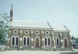 |
| Church |
Sukkur is a
hub of many small and large scale industries. Among important industries are
cotton textiles, cement, leather, tobacco, paint and varnish, pharmaceuticals,
agriculture implements, hand pumps, lock making, rice-husking, and sugar. Small-scale
cottage industries comprise hosiery, boat making, fishing accessories, thread
ball spooling, trunk making brass-wares, cutlery and ceramics. Being an
agricultural city, crops like rice, maize, cotton, tomatoes, peas wheat,
barley, gram and melons are sown here. Sukkur is famous world over, for its
delicious dates. Sukkur also holds a large number of riverine forest on the
course of Indus. These tropical forests are found within the protective
embankments on either side of Indus. During 1997-98 the total area under
forests was 510 km² which yielded 55,000 cubic feet (1600 m³) of timber and
27000 cubic feet (760 m³) of firewood besides other miner products.
OLD SUKKUR IN SINDH
 |
| Choohar Das Garden Old Sukkur |
Originally Sukkur, Rohri and Bukher
were all connected by land. A great earthquake during the 11th century
changed the course of the river Indus from Arror to a different side of Rohri,
with the result that the land, which connected Sukkur, Rohri and Bukher, was
divided into three parts and the river flowed in between. Sukkur was on one
side, Rohri on the other and Bukher was in between.
There are various versions as to how
Sukkur was given its name. The popular version is that there were fields of
Sugarcane and Sugar factories in the vicinity of Sukkur. So Sukkur seems to be
the distorted version of the word ‘Shaker’ which means ‘Sugar’. There is another version, which
seems to be more authentic and convincing, thats because there was plenty to
eat and plenty to enjoy, things were inexpensive and people at large were
comfortable and happy. The word Sukkur seems to have been derived from the word
‘Sukh’ which means Comfort.
 |
| Gin House Old Sukkur |
Sukkur was the third most important
town of SINDH . It was an important commercial and industrial centre of upper
Sindh. It is said that Sukkur became a very important Ship building port
and two ships were built one in the year 1835 named Indus and the other
in the year 1843 named Satellite. Sukkur assumed great importance in
business, trade and other activities especially after the conquest of Sindh by
the British in 1848.
Sukkur gained further importance
after the construction of the famous Sukkur Barrage (Dam) on the river Indus
making Sindh the granary of India.
Important Places of Sukkur.
A) Bunder Road
Among the important places of Sukkur
was the Bunder Road which was beside the river Indus. It was somewhat similar
to Marine Drive at Bombay
 |
| Sadh Bela |
B) Sadhubela
The other important place of
attraction was the temple known as Sadhubela which was on an island in the
middle of the river Indus. It was built artistically of marble and
was surrounded by a garden of great beauty which had varieties of birds
including the peacock freely living in full protection. The head of the
Sadhubela Ashram before Partition was a Saint known as Swami Harinamdasji,
who besides being a religious scholar, was also a man of the people. He helped
solve many disputes between the residents of Sukkur and prevented unnecessary
litigation and expenditure . He was highly respected and admired by one and
all.
 |
| Bathing Ghat |
C) Ghats
On the bank of the Indus river were
beautiful ghats where people took bath and prayed on holy days like ChetiChand.
Old & New Sukkur
Sukkur was divided into Old and New
Sukkkur only by a railway line and the distance between them was only half a mile.
The population at the time of Partition of New Sukkur was about 80,000 and that
of Old Sukkur was about 10,000.
Old Sukkur was connected to an
important town, Rohri, by a Pillarless bridge known as the Landsdowne Bridge
which was one of the few bridges of this type in those days. The people of Old
Sukkur had very close social and cultural relations with the people of Rohri.
Although the population of Old Sukkur was much less than that of New Sukkur,
the residents of Old Sukkur were very well off and had their own businesses.
 |
| Sukkur on Right Bank of Indus River |
Most residents had Shops, Factories and other business concerns located in New
Sukkur. While the people of New Sukkur had emigrated to New Sukkur from the
surrounding villages and rural areas and did not have close relationships with
each other, the residents of Old Sukkur had very close ties with each other and
were like one big family.
 |
| Dev Samaj School |
Many residents of Old Sukkur were related to
each other either by ties of Blood or Marriage. In Old Sukkur, there was a
hospital, Girls school, Narishala, a Bhavan and a Public Library apart from a
large number of parks and gymnasiums. There was no political or religious
rivalry among the people. Muslims and Hindus lived in Old Sukkur with perfect
understanding and amity and participated in each others' festivals without
reservations.
Municipal Vernacular School / Mules
English School
Municipal Vernacular School was
established in the year 1884 with four primary standards.
 |
| Entry of Mules School |
Subsequently
two more standards called as Pahiryon and Biyon Angrezi were added.
However, later on adjacent to this School another school with six English
standards called Angrezi or Mules School was established in the year 1903
thereby the two additional standards were wounded up from Municipal School
. Thus there were two schools, one Municipal Vernacular school
called Primary School with four Sindhi standards and another Mules or
Angrezi School with six English standards. Thereby making in all 10
standards for qualifying for Matriculation examination of Bombay University.
Both these school were established
with untiring efforts of Master Khanchand Balani.
 |
| Lansdowne Bridge |
Although during Meers` rule there
was no arrangement for children`s education from Government`s side, but later
during the British rule Sindhi was taught in School in Guband , that was also
called as Qube varo school, that was opp. Sukkur Jail. That Guband with
40` ht. has eight sides, that is why it was called Athan Passan Vro
Guband. In 1984 when Municipal Vernacular school was established, the
school at Guband was wound up. But soon at the
Qube vari place, Mian Abdulah
Peerzada starded K.G.school for children, where besides Kinder Garden
education, children were taught games, music and dance, children used to attend
the K.G. school with great interest.
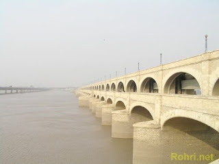 |
| Lloyd Barrage or Sukkur Barrage |
Sukkur Barrage
The Sukkur Barrage has 66 Gates. The Sukkur barrage (formally
called Lloyd Barrage), built under the British Raj on the Indus river, controls one of the largest irrigation systems in the
world. It was designed by Sir Arnold Musto KCIE, and constructed under the
overall direction of Sir Charlton Harrison,
KCIE, as Chief Engineer. Construction of the barrage was started in 1923 and
completed in January 1932. The 5,001 feet (1,524 m) long barrage is made
of yellow stone and steel and can water nearly 10 million acres (40,000 km2)
of farmland through its seven large canals. Some of the canals are larger than
the Suez Canal.
 |
| Lansdowne Bridge |
In November 2004, the government of Pakistan initiated a
rehabilitation project to revitalize its water storage capacity and
distribution efficiency. The project was completed in July 2005, (with less
than the allocated amount of Rs. 887 million). Experts believe that the
rehabilitation of the barrage has enhanced its efficiency for another 60 to 70
years.
Rohri
 |
| Imam Bargah Rohri |
Rohri or Lohri, 27° 41’
North Latitude, 68° 56’ East
Longitude, headquarter of the taluka (tehsile) of that name, is a Municipal
Town.
The town is situated on the left bank of
the river Indus (Sanskrit, Sindhu; Greek, Sinthes; Latin Sindus [from Bukkur in
Sukkur to the sea the river is known familiarly among the people of the
province as the Darya]), on a rocky eminence of limestone
interspersed with flints, which is terminated abruptly on the western side of a
precipice 12 meters high rising from the bank of the river, which during the
inundation attains a height of about 05 meters above its lowest level.
On the southern side the aspect of the whole place has been changed by the operations of the Railway Company, which has
cleared a wide space fir its yards by blasting the hills and filling up the
hallows obtaining at the same time immense quantities of good stone.
.jpg)
The interest of town lies mainly in
its history which begins from the stone
age, for it is evident, from the quantity of flint cores and flakes found in
the river bed at Rohri and on the surrounding
hills (proceeding of the Asiatic Society of Bengal 1975, page 134) by
Lieutenant Twemlow, R.E., and afterwards by Mr. John Tate, that Neolithic man
has, at one time, a flourishing settlement at this place. Dr. Blanford
pronounced these cores to be more carefully formed than any previously found in
India and so far superior to all ordinary forms of the same other places. There
is a wide gap between Neolithic man and the Arab invasion of Sindh, at the time
of which there was almost certainly no town on the present site which
was not then on the course and made a passage for itself through the hills
between the present Rohri and Sukkur, the two towns probably grew simultaneously on its left and right
banks respectively under the protection of the fortress which soon occupied
Bukkur. From a very early period Rohri acquired a sacred character, which was
enhanced when the Saiyids who has settled in Bukkur were removed by Shahbeg
Arghun and compensated with land and privilege at Rohri. Its history as a
scared place can be gathered from a description of the principle shrines and
relics.
There are three prominent hills (nummulitic limestone, low range on the
northern extremity, run southwards from that point to Khairpur District
boundary), namely “Kalka” hill
at Arore, “Laheri” hill at Rohri and “Shadi Shaheed” hill at Kandhra.

In 1975-6, the Cambridge Archaeological Expedition made
a preliminary survey of the Paleolithic sites in the Rohri Hills. According to
their findings, the Rohri Hills were a source of chart for the manufacture of the parallel-sided blades used by the Harappan
culture of 2300-1750 BC. The most clearly differentiated Paleolithic site in
the Rohri Hills was at their southern end, near the village of Chancha Baloch
and only four kilometers from the pre-Harappan settlement of Kot Diji. Spread over
an area of about 5,000 square meters,
on a largely sand- free area between the dunes, are found Middle and Upper
Paleolithic artifacts and factory debris . An extensive series of working floors were also found close to a hamlet known as Nawab Punjabi.
The discovery of factory sites representing all phases of the Stone Age in
the lower Indus Valley has added more depth to our understanding of
civilization in prehistoric Sindh. Rohri was one of the place most affected by
the departure of the caste Hindu in 1947.
 |
| Satyun jo Aastan |
Satyun jo Aastan
Satyun Jo Aastan (the place for virgins sisters) on one of the little hills
that rise out of the river bank on the south there is a level platform on
which are many carved gravestones like those on the Makli Hills at Thatta,
which chain ornament and panels of Arabic quotations from the Holy Quran. The whole space between the
graves is paved and a flight of step leads up to
the platform from the South-side. Enameled tiled work is freely used on these
tombs, most of which are dated
1018 to 1301 AH., that is between 1609 and 1883 AD. The principal grave is that
of Mir Kasim one of the Sabzwari Shahids dated 1018 AD. This was probably the
grave that sanctified the place, and a lamp post and lamp are placed in front
of it still, and it gives the name of Than Kasim Shah to the hill. But the name
of which it is more generally known is the hill of the seven virgins from the
building on the southern side called Satbhain, which consist of a row of
shallow rooms connected externally with colored tiles.

These cells are said to
have been occupied by seven virgins, who had taken a vow never to look upon the
face of man. Sir Richard Burton, however, maintains that this derivation is
wrong, ignorant people having perverted Sati-na-jo-Than or seat of the Satis
(i.e. celibate women) in to something which means seven.
Pano Aqil is a taluka of Sukkur District in the Sindh province of Pakistan. It
is located approximately 40 kilometres (25 mi) north of the capital Sukkur. Pano
Akil Cantonment,
Pakistan's largest cantonment, is located here.
 |
| Kot Bula |
The Mohallas in this city include Fouji Mohalla, Abbasi
Mohalla, Sofi Mohalla, Mehran Colony, Indher Colony, Basheerabad, Shaikh
Muhalla, Mandar Gali, Masan Muhalla, Gharibabad, Bashirabad and Irrigation
Colony. It consists of 12 union
councils and 516
villages.
Pano Akil is a railway station on Rohri-Lahore main railway 24 miles from Rohri. The town was founded in the 18th century by Akil Khan. In 1904, the mahal of Pano Akil was converted into a taluka. The new District was divided into three subdivisions. Ghotki Taluka of Sukkur District, Sind, Bombay, lying between 27� 40' and 28� 11' N. and 69� 4' and 69� 35' E., with an area of 518 square miles, including the Pano Akil wa^a/(168 square miles). The population rose from 67,743 in 1891 to 72,019 in 1901. The tdluka contains one town, Ghotki (population, 3,821), the headquarters; and 129 villages. The density, 139 persons per square mile, is much above the District average. The land revenue and cesses in 1903-4 amounted to 2-2 lakhs. The taluka is liable to floods, and depends for the irrigation of its jowar and wheat upon small canals leading direct from the Indus. The zamindars were mostly small holders and impoverished. Much forest land fringes the banks of the river.
Accessibility
The city can be accessed by rail as it is
located on the main railway line of Pakistan. The national highway also passes
by the west of the city, providing easy access by Road. Similarly, public
transport is easily available for various cities including Karachi, Islamabad, Lahore and Sukkur. Sukkur Airport is about at an one and half hour driving distance
from the city. The city is connected via a grid of roads and streets, most
accessible by car.
 |
| Noor Mosque |
Economy
Pano Aqil is basically an agricultural
area, as its land is fertile while water is available in appropriate quantity.
Some agricultural industries include
Mahar Cotton Factory, Habib cotton (Indher Colony), Mahar Floor Mill, Najeeb
Boon Mills, Bhutto Fruit Farm, Wood Factories and Fruit Farm. It supplies major
amounts of vegetables, fruits and cotton crops to the other parts of country,
oil of pano akil is so famous also. Pano Aqil is the largest supplier of Lady
finger of Pakistan.
 |
| Mehran Model School |
Education
The educational facilities at Pano Aqil
are basic. The Garrison School and College provide the main education in the
city. Mehran Model School & Sec: College, Al-Shahabaz School, Roshan Tara
School, Govt Boys Higher Secondary Schools, Degree College Pano Aqil, Govt
Girls College and Govt High school, Nobel Model School, City School, Govt.
Higher Secondary school sultanpur so many other colleges and schools are there
in Pano Akil City.
There are Also Educational Academies for
IX, X, XI, XII and Specially for Pre Entry Test Preparation. 1. Ideal
educational academy 2.Pano Aqil Educational academy 3.Iqra Educational Academy
& many others....
 |
| Mehran Model School Park |
The Large Islamic Educational Institutes
at Pano Akil. Jamia Madinat ul uloom,Jamia Taalim ul Islam (Bannaat) Indher
colony,Jamia Tahfeezul Quraan Indher colony,Dar ul Uloom ul Islamia Indher
colony,Jamia Hamadiya salahi chacher,Jamia Anwar ul Quraan , Jamia Haleji
shareef,Jamia Gol Makki Masjid,madarsa noor-e-mustafa tahiria naqshbandiya
village sorho tulka (PNL) etc.... by notables of pano akil.
Demographics
Pano Aqil's estimated population is
245,187 in an area of 3,193 square kilometres
(1,233 sq mi)Mahar,Kalwar,[^Bullo^],Chachar, {Pitafi } Mughal, Malik,
Kalhoro, Jiskani Sayed, Indhar,thaheem, wagho Abbasi, Jatoi, Qazi, Bhayaa, Samejo, Indher, Shaikh, Kalhora, Bhutto, Mahar, Channa, Arain, Simair, Sahita, Soomra, Mahesar, Korai, Mirani, Maka, Mangi, Almani, Jhullan, Bhellar, Mari, Jarwar, Muhammadi, Lanjar, Lashari, Khaldi,and Umrani tribes live in the taluqa. There is a large Hindu community. Some Christian families also live and work in the city.
Syed are also living in Pano Akil.
Pano Aqil Cantonment
 |
| High Court Sukkur |
 |
| Govt. High School Sukkur |
 |
| Masoom Shah jo Manaro |
 |
| Mosque made by Mohammad in Qasim |
 |
| Mohammad Bin Qasim Park |
 |
| Telenor Globe Sukkur |
.jpg) |
| Tomb of Khuwaja Khizr (Zahir Pir) |
 |
| Mahadev Temple |
 |
| Street of Old Sukkur |
 |
| Sadaruddin Shah |
 |
| Satyun jo Aastan |
 |
| Satyun jo Aastan
|
 |
| Public School Sukkur |
 |
| Taluka Munciple Sukkur |
 |
| Old Sukkur Jail |
 |
| Kalka Devi Aroorr |
 |
| Masoom Shah Bakhri |
 |
| Mohammad Bin Qasim Mosque |
 |
| Rohri |
 |
| Zazree Mubarak Rohri |
 |
| Karbala Moalla |
 |
| Jamay Masjid (Waar Mubarak) |
 |
| Satyun jo Aastan |
 |
| Rohri Railway Station |


.jpg)


.jpg)


this is a ggod diary of disrict ghotiky and also good writer of the diary
ReplyDeleteWeldone Kavi, Its a great job you have done. now we can found information about all districts of Sindh at one place and in a new form.
ReplyDeletelast snap is not Rohri Railway Station but it is Sukkur Railway Station. Please correct.
ReplyDeleteEngr. Waseem from Railway Sukkur.
Bhai Waseem Kesy Engr ho....inty budy huroof men likha hy Pano Aqiil Chhaoni..aur app kehty hen Sukkur Railway Sta hy....!!!!!
DeleteMeer Hamza
The information you have posted is very useful. The sites you have referred was good. Thanks for sharing..High Efficiency Irrigated System Sindh
ReplyDeleteDear Blogger,
ReplyDeleteYou have done this superbly. I need your help, would you like to send me the Sukkar map.
I will be grateful to you.
Regards
Dr Imran A Khan
imranak32@uok.edu.pk
MASHA ALLAH very well written very imformative
ReplyDeleteThis information is meaningful and magnificent which you have shared here about the I-investonline. I am impressed by the details that you have shared in this post and it reveals how nicely you understand this subject.
ReplyDeletehttps://ahrealestatemarketing.com/portfolio/capital-smart-city/