PROFILE

INTRODUCTION
Ghotki District is a district of Sindh Province, Pakistan. Mirpur Mathelo is the Head Quarter of Ghotki District. The town is located at 28°1'0N 69°19'0E with an altitude of 72 meters (239 ft). Pano Aqil army cantonment is also near Ghotki city but in Sukkur District. Ghotki district is spread over an area of 6975 square kms. The length is 50 miles from east to west and breadth is about 60 miles. Ghotki city is situated near National Highway alongwith railway line which crosses from the center of the city.
1. Ghotki
 |
| Map of Ghotki |
Ghotki has four seasons i.e. Winter, Spring, Summer and Autumn around the year. Ghotki has very fertile land and main crops it produces are Cotton, Wheat, Sugar cane and Rice. Ghotki is sort of industrial area in Interior Sindh since it hosts Oil and Gas Development Corporation (OGDC), Engro Chemicals and Fauji Fertilizers. Popular places of Ghotki main city are Sessions Court, Circuit House, Shahi Bazzar, Ladies Market, Jamia mosque, Government Park, Rehmoowali Park. Ghotki district has following five Talukas.
1. Ghotki
2. Mirpur Mathelo.
3. Khangarh
4. Daharki
5. Ubauro
EDUCATIONAL INSTITUTIONS
College, Paramedical College, Vocational Training Centers. Etc.
BANKS BANKING/FINANCIAL INSTITUTIONS
14.POTENTIAL PROJECTS IDENTIFIED BY SMEDA
HISTORY
Ghotki was founded by an ambassador general of Raja Ibn Selaj Birhman (a relative of Raja Dahar of Sindh)in 637 A.D (15th year of Hijra) named Hath Sam who set up an army settlement/camp after defeating a Muslim Army of Arabia. The camp later assumed the shape of a village on 17th Shaban in 17th year of Hijra (639 A.D) when people of different tribes came to settle here. Two years later the people deserted this village and it again became a land of birds and animals. In year 695 A.D certain fishermen came here and settled and named the village as "Miani". But when the river changed its course the people left the village again to the mercy of jackals. In 712 A.D Mohammad Bin Qasim conquered the Sindh by defeating Raja Dahar. Ghot Ibn Samed Ibn Patel a Hindu born to a son of Raja Dahar was settled here. Ghot voluntarily and happily accepted the Islam on the hands of Arabs and married to a new Muslim -Emna according to Shariat-e-Mohammadi and gave birth to a baby boy Tameer from whom the Ghota tribe came into being. Arabs awarded many jagirs to Ghotas and named this village as "Dharwali" to honour their grandfather. Subsequently as the Ghotas progressed quantitatively and culturally the name of village was changed from Dharwali to Loh-e-Saheban when a Saint came from Bhaghdad whose name was Syed Mubarak Shah Jillani Baghdadi. After the British conquest of Sindh province in 1847, they awarded huge blocks of irrigated, fertile land to the Ghotta tribal chieftains in return of their loyalty to the British. Gradually, the town's name changed into Ghotki (of Ghottas) in lieu of Loh-e-Saheban. Jamia Masjid ("Jamia" Mosque)..
 |
| Jaamay Mosque |
In the Ghotki there is a historical grand mosque known as Jamia Masjid Ghotki. According to a hand-written book "Sahih-ul-Subaten" of Gul Mohammad, that is available in library of the Madrassa Qasim-ul-uloom of the Ghotki, Syed Abu Saleh Moosa Shah Hussiani Jillani who was the near fellow of the famous saint Hazrat Sultan Baho of district Jhang from He was titled as Ghous Moosa shah, in the days of Mian Noor Mohammad S/O Mian Yaar Mohammad Abbasi / Kalhoro constructed this Mosque at this time the name of city was Loh-eSaheban which means land of purity or place of purified persons means (Jillani Syeds belongs to Prophet's Family). The Jamia Masjid is a large mosque.3.
 |
| Main Entrance of the city |
POPULATION
The population of Ghotki district, presently comprising five Talukas is 10,37000 and the average annual growth rate of population is 3.26%. Population density of 159.6 persons / sq. km. House hold size of district is 5.5 persons. Rural Population of the district is 83.67%. Urban population of the district is 16.33 %. Percentage of Population by Religion and Rural/Urban Areas, 1998 Religion All Areas Rural Urban
- Muslim 93.06 94.90 83.64
- Christian 0.14 0.07 0.51
- Hindu (Jati) 6.17 4.58 14.29
- Ahmadi 0.08 0.06 0.18
- Scheduled Caste0.5 0.34 1.35
- Others 0.04 0.05 0.02
Only one AFP case was found from Hindu community, which was negative adequate stool specimen and discarded as GBS. Routine as well as SIA coverage among Hindu community children was 89% and 100% respectively during the March & April rounds 2002.
AGRICULTURE SYSTEM
The major crops during Rabi season are wheat, mustard, jambho, grams and kharif seasons are cotton paddy, corn, sugarcane, jawar, guar, bajra, sesamum.
 |
| Baab Mir Khalid Hussain Lund Mirpur Mathelo |
5. SWEETS
The famouns sweets of Ghotki district are Perra, which is exported all over the country.
6. HORTICULTURE
Climate of Ghotki is suitable for growing fruit and vegetable crops, like banana, dates, mangoes, lemon, carrot, redish, cabbage, spinach, onion, green chilleies, etc.
LIVESTOCK
Ghotki district is rich in livestock i.e. cattle, buffalo, goat and sheep are found in every part of district Ghotki and there are many dairy farms in district Ghotki.
NUMBER OF DAIRY AND LIVESTOCK
Lives stock Numbers (in thousands)
Cattle 198
Buffalo 189
Sheeps 63
Goats 371
Camels 2.25
Horses 28.
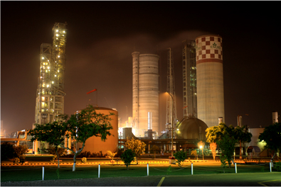
Industries
Detail of industries and factories established in Ghotki district is given below;
1. Sugar Mills (02)
2. Rice Mills (28)
3. Flour Mills (15)
4 Ice Factories (10)
6. Oils Mills (20).
7. Stablizer and UPS making (02).
8. Handicrafts.
9. Candle Making.
10. Spice Factories.
11. Fertilizers (02).
 Fauji Fertilizer Company
 FFC commenced commercial
production of urea in 1982 with annual capacity of 570,000 metric tons.Through
De-Bottle Necking (DBN) program, the production capacity of the existing plant
increased to 695,000 metric tons per year. Production capacity was
enhanced by establishing a second plant in 1993 with annual capacity of 635,000
metric tons of urea.FFC participated as a major shareholder in a new DAP/Urea
manufacturing complex with participation of major international/national
institutions. The new company Fauji Fertilizer Bin Qasim Limited (formerly
FFC-Jordan Fertilizer Company Limited) commenced commercial production with
effect from January 01, 2000. The facility is designed with an annual capacity
of 551,000 metric tons of urea and 445,500 metric tons of DAP, revamped to
670,000 metric tons of DAP. In the year 2002, FFC acquired ex Pak Saudi
Fertilizers Limited (PSFL) Urea Plant situated at Mirpur Mathelo, District
Ghotki from National Fertilizer Corporation (NFC)
through privatization process of the Government of Pakistan. It has
annual production capacity of 574,000 metric tons urea which has been revamped
to 718,000 metric tons urea in 2009. This acquisition at Rs. 8,151 million
represented the largest industrial sector transactions in Pakistan at that
time. Pak-Saudi Fertilizer Ltd. (PSFL) is a large ammonia/urea complex
with a daily capacity of 1000 metric tons of ammonia and 1740 metric
tons of urea. The complex is situated 2.5 km north-east of Mirpur Mathelo,
104 km from Sukkur. The plants cover an area of 433 acres, while
the housing colony for employees is spread over an area of 39 acres. There are
235 officers and 650 workers employed on the project. The project was
financed by the Saudi Arabian Government and the Asian
Development Bank as under:
FFC commenced commercial
production of urea in 1982 with annual capacity of 570,000 metric tons.Through
De-Bottle Necking (DBN) program, the production capacity of the existing plant
increased to 695,000 metric tons per year. Production capacity was
enhanced by establishing a second plant in 1993 with annual capacity of 635,000
metric tons of urea.FFC participated as a major shareholder in a new DAP/Urea
manufacturing complex with participation of major international/national
institutions. The new company Fauji Fertilizer Bin Qasim Limited (formerly
FFC-Jordan Fertilizer Company Limited) commenced commercial production with
effect from January 01, 2000. The facility is designed with an annual capacity
of 551,000 metric tons of urea and 445,500 metric tons of DAP, revamped to
670,000 metric tons of DAP. In the year 2002, FFC acquired ex Pak Saudi
Fertilizers Limited (PSFL) Urea Plant situated at Mirpur Mathelo, District
Ghotki from National Fertilizer Corporation (NFC)
through privatization process of the Government of Pakistan. It has
annual production capacity of 574,000 metric tons urea which has been revamped
to 718,000 metric tons urea in 2009. This acquisition at Rs. 8,151 million
represented the largest industrial sector transactions in Pakistan at that
time. Pak-Saudi Fertilizer Ltd. (PSFL) is a large ammonia/urea complex
with a daily capacity of 1000 metric tons of ammonia and 1740 metric
tons of urea. The complex is situated 2.5 km north-east of Mirpur Mathelo,
104 km from Sukkur. The plants cover an area of 433 acres, while
the housing colony for employees is spread over an area of 39 acres. There are
235 officers and 650 workers employed on the project. The project was
financed by the Saudi Arabian Government and the Asian
Development Bank as under:
 Asian Development Bank Rs 50
million
Asian Development Bank Rs 50
million
 OGDCL is the national oil & gas company of
Pakistan and the flagship of the country’s E&P sector. The Company is the
local market leader in terms of reserves, production and acreage, and is listed
on all three stock exchanges in Pakistan and also on the London Stock Exchange
since December 2006. The Company is all set to ride the wave of E&P
activity, equipped with its Vision & Mission, Business and Strategic Plan,
a debt-free and robust balance sheet and healthy cash reserves. The Company is
ready to take on the challenges of a volatile E&P industry.
OGDCL is the national oil & gas company of
Pakistan and the flagship of the country’s E&P sector. The Company is the
local market leader in terms of reserves, production and acreage, and is listed
on all three stock exchanges in Pakistan and also on the London Stock Exchange
since December 2006. The Company is all set to ride the wave of E&P
activity, equipped with its Vision & Mission, Business and Strategic Plan,
a debt-free and robust balance sheet and healthy cash reserves. The Company is
ready to take on the challenges of a volatile E&P industry.
 To revive exploration in the energy sector the
Government of Pakistan signed a long-term loan Agreement on 04 March 1961 with
the USSR, whereby Pakistan received 27 million Rubles to finance equipment and
services of Soviet experts for exploration. Pursuant to the Agreement, OGDC was
created under an Ordinance dated 20th September 1961. The Corporation was
charged with responsibility to undertake a well thought out and systematic
exploratory programme and to plan and promote Pakistan's oil and gas prospects.
To revive exploration in the energy sector the
Government of Pakistan signed a long-term loan Agreement on 04 March 1961 with
the USSR, whereby Pakistan received 27 million Rubles to finance equipment and
services of Soviet experts for exploration. Pursuant to the Agreement, OGDC was
created under an Ordinance dated 20th September 1961. The Corporation was
charged with responsibility to undertake a well thought out and systematic
exploratory programme and to plan and promote Pakistan's oil and gas prospects.
 Engro Corporation Limited is one of Pakistan’s
largest conglomerates with businesses ranging from fertilizers to power
generation.
Engro Corporation Limited is one of Pakistan’s
largest conglomerates with businesses ranging from fertilizers to power
generation.
 From its inception as Esso Pakistan Fertilizer
Limited in 1965 to Engro Corporation Limited in 2010, Engro has come a long way
and will continue working towards its vision of becoming a premier Pakistani
company with a global reach.
From its inception as Esso Pakistan Fertilizer
Limited in 1965 to Engro Corporation Limited in 2010, Engro has come a long way
and will continue working towards its vision of becoming a premier Pakistani
company with a global reach.
 To boost sales, a full-fledged
marketing organization was established which undertook agronomic programs to
educate farmers of Pakistan. As the nation’s first branded fertilizer
manufacturer, the Company helped modernize traditional farming practices and
boost farm yields, directly impacting the quality of life for farmers and their
families, and for the nation at large. Farmer education programs increased
consumption of fertilizers Pakistan, paving way for Company’s branded urea
called “Engro” –an acronym for “Energy for Growth”.
To boost sales, a full-fledged
marketing organization was established which undertook agronomic programs to
educate farmers of Pakistan. As the nation’s first branded fertilizer
manufacturer, the Company helped modernize traditional farming practices and
boost farm yields, directly impacting the quality of life for farmers and their
families, and for the nation at large. Farmer education programs increased
consumption of fertilizers Pakistan, paving way for Company’s branded urea
called “Engro” –an acronym for “Energy for Growth”.
 By 2009, Engro was fast
growing and had already diversified its business portfolio is as many as seven
different industries. The continual expansions and diversifications in
Company’s enterprises necessitated a broad restructuring in Engro Chemical
operations and management. To facilitate better oversight, Engro Chemical
Pakistan was converted into a holding company named Engro Corporation, and its
fertilizer business was subsequently demerged to a newly formed Engro
subsidiary –Engro Fertilizers Limited.
By 2009, Engro was fast
growing and had already diversified its business portfolio is as many as seven
different industries. The continual expansions and diversifications in
Company’s enterprises necessitated a broad restructuring in Engro Chemical
operations and management. To facilitate better oversight, Engro Chemical
Pakistan was converted into a holding company named Engro Corporation, and its
fertilizer business was subsequently demerged to a newly formed Engro
subsidiary –Engro Fertilizers Limited.

FFC was incorporated in 1978
as a private limited company. This was a joint venture between Fauji Foundation
(a leading charitable trust in Pakistan) and Haldor Topsoe A/S of Denmark.
The initial share capital of
the company was 813.9 Million Rupees. The present share capital of the company
stands above Rs. 8.48 Billion. Additionally, FFC has more than Rs. 8.3 Billion
as long term investments which include stakes in the subsidiaries FFBL, FFCEL
and associate FCCL.

Saudi Arabian
Government Loan US$ 50 million
Saudi Funds for Development Rs
97 million

Work on the complex commenced on 18 April 1975
and was completed on 30 September 1980; commercial production of urea started
in October 1980. The basic raw material is natural gas, available at the nearby
Man gas field, about 8 kilometers from the plant. The gas is brought to the
plant site through a 16-inch diameter pipeline and is used as fuel as well as
feed stock.
The company had paid off all of its long-term
foreign loans by the end of December 1990.
Qadirpur Gas Field (OGDCL)
 OGDCL is the national oil & gas company of
Pakistan and the flagship of the country’s E&P sector. The Company is the
local market leader in terms of reserves, production and acreage, and is listed
on all three stock exchanges in Pakistan and also on the London Stock Exchange
since December 2006. The Company is all set to ride the wave of E&P
activity, equipped with its Vision & Mission, Business and Strategic Plan,
a debt-free and robust balance sheet and healthy cash reserves. The Company is
ready to take on the challenges of a volatile E&P industry.
OGDCL is the national oil & gas company of
Pakistan and the flagship of the country’s E&P sector. The Company is the
local market leader in terms of reserves, production and acreage, and is listed
on all three stock exchanges in Pakistan and also on the London Stock Exchange
since December 2006. The Company is all set to ride the wave of E&P
activity, equipped with its Vision & Mission, Business and Strategic Plan,
a debt-free and robust balance sheet and healthy cash reserves. The Company is
ready to take on the challenges of a volatile E&P industry.
Establishment of OGDCL

As an instrument of policy in the oil and gas
sector, the Corporation followed the Government instructions in matters of
exploration and development. The day to day management was however, vested in a
five-member Board of Directors appointed by the Government. In the initial
stages the financial resources were arranged by the GOP as the OGDC lacked the
ways and means to raise the risk capital. The first 10 to 15 years were devoted
to development of manpower and building of infrastructure to undertake much larger
exploration programmes.
ENGRO Fertilizer Company
In the interest of better managing and
overseeing businesses of subsidiaries and affiliates that are currently part of
Engro’s capital investments, Engro Chemical Pakistan Limited converted into a
holding company structure. As part of this process, two major changes occurred
with effect from January 1, 2010; Engro Chemical was renamed as Engro
Corporation Limited and it demerged and transferred its fertilizer business
into a separate wholly owned subsidiary, Engro Fertilizers Limited. Currently
Engro Corporation’s portfolio consists of seven businesses which include
chemical fertilizers, PVC resin, a bulk liquid chemical terminal, industrial
automation, foods, power generation and commodity trade.
Besides providing the long term vision for the
company and overseeing performance of the subsidiaries and affiliates, Engro
Corporation Limited is also responsible for allocation of capital, management
of talent, leadership development, HR guiding policies, leadership role in
public relations and CSR activities, control structures, legal and IT support.

In 1957, Pak Stanvac –an
Esso/Mobil joint venture –stumbled upon vast deposits rich in natural gas in
Mari while pursuing viable oil exploration in Sind. With Pak Stanvac focused
exclusively on oil exploration, the discovery shifted the impetus to Esso which
decided to invest on the massive industrial potential of Mari gas field. Esso
proposed establishment of a giant urea plant in Daharki, about ten miles from
the Mari gas fields, which would use natural gas produced as its primary raw
material to turn out urea fertilizer.
Talks with the Government of
Pakistan bore fruit in 1964, and an agreement was signed allowing Esso to set
up a urea plant with an annual capacity of 173,000 tons. Esso brought in
state-of-the-art design; commercially tried facilities; and a highly
distinguished pool of technical expertise to ensure a smooth start up. Total
investment made was US$ 46M –the single largest foreign investment in Pakistan
to date then. The plant started production on 4 December 1968 –a few months
late and with less than 10 % over run on the original budget.

In 1978, Esso became Exxon as
part of an international name change. The Company was therefore renamed Exxon
Chemical Pakistan Limited.
In 1991, Exxon decided to
divest its fertilizer business on a global basis. The employees of Exxon
Chemical Pakistan Limited –in partnership with leading international and local
financial institutions –bought out Exxon’s 75% equity. This was, and perhaps still
is, the most successful employee buy-out in Pakistan’s corporate history.
Renamed Engro Chemical Pakistan Limited, the Company went from strength to
strength with its consistent financial performance; growth of its core
fertilizer business; and diversification into other enterprises.
A major plant capacity upgrade at Daharki coincided with the employee led buy-out in 1991. Engro also relocated fertilizer manufacturing plants from the UK and US to its Daharki plant site –an international first. Beginning in 1994, Engro Chemical Pakistan Limited moreover started venturing into other sectors: foods, energy, industrial control and automation, PVC resin manufacturing and marketing, and chemical terminal and storage.
A major plant capacity upgrade at Daharki coincided with the employee led buy-out in 1991. Engro also relocated fertilizer manufacturing plants from the UK and US to its Daharki plant site –an international first. Beginning in 1994, Engro Chemical Pakistan Limited moreover started venturing into other sectors: foods, energy, industrial control and automation, PVC resin manufacturing and marketing, and chemical terminal and storage.

The demerger acquired the
approval of High Court of Sind on December 9, 2009 after obtaining the
requisite approvals from creditors and shareholders of the Company. The
demerger became effective from January 1, 2010. Subsequently, all fertilizer
business assets and liabilities have been transferred to Engro Fertilizers
Limited against the issue of shares to the Company.
Future
prospects for Engro Fertilizers look bright as the Company recently undertook
its biggest urea expansion project to date. Its newly constructed Prill Tower
stands tall at 125 meters –dubbed the tallest structure in Pakistan. The total
cost of this expansion is approximately US$ 1.05 Billion, with the expanded
facility looking set to make Engro the biggest urea manufacturer in Pakistan,
besides substantially cutting the cost of urea imports to national exchequer.
9. TRADE AND TRADE CENTER.
Ghotki district is main trading center of whole district it has a famous galla mandi which is the main source of agriculture trade in the city and taluka Daharki and Khangarh of district is also important trading center for cotton wheat rice and sugar cane. The main items of trade like cotton, wheat, rice and onion are supplied to other parts of the country.
 |
| Degree College |
Educational Institutions are Primary School (2001), Middle Schools (48), High
Schools (32), Higher Schools (04), Govt. Degree Colleges (03), Poly technical
College, Virtual University, Private Schools, Computer Training Institutes, Law
 |
| VU Campus |
BANKS BANKING/FINANCIAL INSTITUTIONS
In Ghotki district Habib bank, National Bank, Allied Bank, United Bank, Askari
Bank, Khusuhalli Bank, Micro Finance Bank, Bank Al-Habib, ZTBL, Alfalah
Bank.
ATM Machines are also working in few banks.
HOTELS
HOTELS
Following hotels are working in Ghotki.
1. Shelton Hotel
2. Green Hotel
3. City Hotel.
4. Prince Hotel.
5. Serina Hotel.
6. Dileep Hotel.
13.PUBLIC PARKS
1. Ali Muhammad Khan Park
2. Public Park
3. Rehmoowali Park
4. Chawla Park
 |
| Amaara High School |
Seed Processing Unit (Wheat and Cotton)
Dairy Milk Plant
Animal and Poultry Feed
Biscuit Factory
Agriculture Implement Industry
Amusement Park (zoo, fun land and water park).
Momal- Ji- Mari is the fortress at the distance of about 15 kilometer from the Ghotki town in the village known as "Mathelo". It is believed that in the year 536 B.C. in the earth-quake Mathelo town ruined along with other small towns of the Sindh. Iranian King Dara-II partly reconstructed the Mathelo. Mathelo fortress was reconstructed in 650 A.D. in the days of Rai Dynasty. During the days of Soomras (from 1051 to 1351 A.D. this family ruled Sindh) Raja Nand Gujar Rajput ruled the northern Sindh, whose capital was Mathelo. Here is the picture, in which Syed Akhtar Shah Bukhari (Chief Editor of Weekly Parahphuti) and Mr. Abdul Majeed (Field Manager of OGDCL Qadirpur) are visiting Momal - ji - Mari.Raja Nand has nine daughters, from them "Soomal" was most intelligent and wisest and "Moomal" was the most beautiful. The Soomra ruler Hamir was keen to marry Moomal but Moomal loved Rano, the minister of Hamir. When Hamir came to know this he invaded Mathelo to take revenge of his insult. In the result of it Mathelo town and its historical fortress got completely destroyed. In the record of department of archeology this fortress is entered under the name of Momal - Ji - Mari and it is described as protected monument. (Referred from "Nai Zindagi" May, 1992).
Saints:
 He belongs to sayed family,
his relation with 10th Imam Ali Naqi (A.S) in the early age. He was sent for
early education at muhmmadpur and ubauro (Tehseel of Ghotki) but he did not
shown interest in education and returned home where he completed Quran in seven
years old, by hearts. His forefathers came from Arabs. They had migrated to
Utch sharief (Punjab) and shifted JahanpurSharief (Sindh) later.In the age of
30 years; he took Baeet from Hazrat Sayed Sahib Dino shah (Wasti Iniyat Shah)
who was mureed of imamul Arfeen Hazrat Bahoo Sultan.
He belongs to sayed family,
his relation with 10th Imam Ali Naqi (A.S) in the early age. He was sent for
early education at muhmmadpur and ubauro (Tehseel of Ghotki) but he did not
shown interest in education and returned home where he completed Quran in seven
years old, by hearts. His forefathers came from Arabs. They had migrated to
Utch sharief (Punjab) and shifted JahanpurSharief (Sindh) later.In the age of
30 years; he took Baeet from Hazrat Sayed Sahib Dino shah (Wasti Iniyat Shah)
who was mureed of imamul Arfeen Hazrat Bahoo Sultan.
He established Khangah (Maikhana) at village Jahanpur Sharief where he teaches the people about the secrets of life and relationship of God. He wrote the book on poetry contened Sindhi, Siraki, Urdu, Hindi and Parsian languages. He played significant role in the spread of Islam by his acts.His life was the symbol of (P.B.U.H). His poetry based on Hub-e-rasool and oneness of God.
Manghan Faqeer (Faqeer Sain)
Momal-ji-Mari
 |
| Moomal Ji Mari |
Saints:
SUFI FAQEER SAYED ANWAR ALI
SHAH BUKHARI SUFI AL QADERI AL
SARVERY
 |
| Anwar Sain |
(The Great Sufi Poet and
Saint
The glorious land of Indus
has witnessed many historical events and Great personalities. Faqeer Sayed
Anwar Ali Shah was one of the Great Sufi poet and saint of the sindh, who
guided the people by his poetry and taught the secrets about the relationship
between the people and the God.
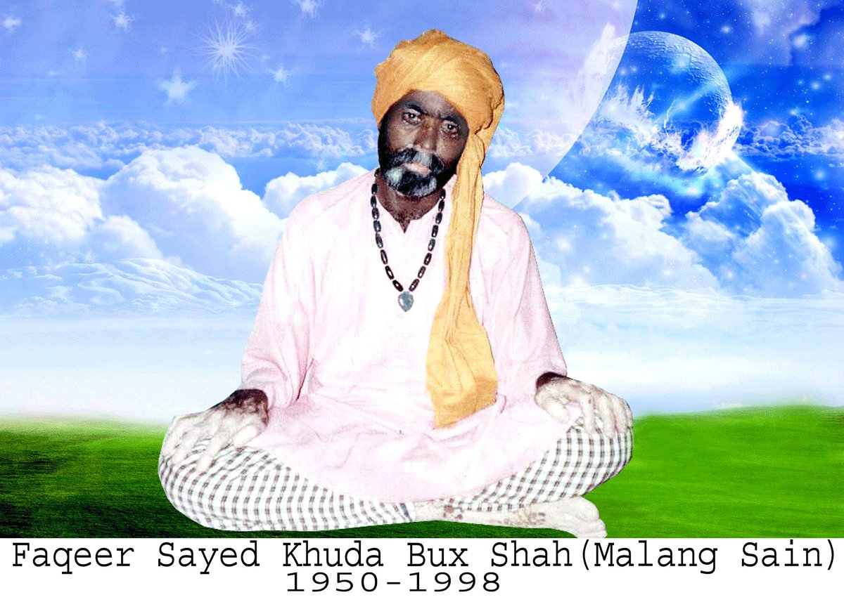
Sayed Anwar Ali Shah was
born in the home of the Makhdoom Sayed Khuda Bux Shah in 1906 at village
Jahanpur Sharief witch is situated on the right side of Qazi Canal. It is about
16km away from Ghotki city, sindh (Pakistan).
 |
| Huzooran Sain |
 He belongs to sayed family,
his relation with 10th Imam Ali Naqi (A.S) in the early age. He was sent for
early education at muhmmadpur and ubauro (Tehseel of Ghotki) but he did not
shown interest in education and returned home where he completed Quran in seven
years old, by hearts. His forefathers came from Arabs. They had migrated to
Utch sharief (Punjab) and shifted JahanpurSharief (Sindh) later.In the age of
30 years; he took Baeet from Hazrat Sayed Sahib Dino shah (Wasti Iniyat Shah)
who was mureed of imamul Arfeen Hazrat Bahoo Sultan.
He belongs to sayed family,
his relation with 10th Imam Ali Naqi (A.S) in the early age. He was sent for
early education at muhmmadpur and ubauro (Tehseel of Ghotki) but he did not
shown interest in education and returned home where he completed Quran in seven
years old, by hearts. His forefathers came from Arabs. They had migrated to
Utch sharief (Punjab) and shifted JahanpurSharief (Sindh) later.In the age of
30 years; he took Baeet from Hazrat Sayed Sahib Dino shah (Wasti Iniyat Shah)
who was mureed of imamul Arfeen Hazrat Bahoo Sultan.He established Khangah (Maikhana) at village Jahanpur Sharief where he teaches the people about the secrets of life and relationship of God. He wrote the book on poetry contened Sindhi, Siraki, Urdu, Hindi and Parsian languages. He played significant role in the spread of Islam by his acts.His life was the symbol of (P.B.U.H). His poetry based on Hub-e-rasool and oneness of God.
His poetry book “Anwar shah
Jo Risalo” was recently published under the guidance of Faqeer Sayed Sakhawat
Ali Shah the 2nd sujjadah nasheen of dargah alia Jahanpur sharief.
He had two sons.
1. Faqeer Sayed Hazoor Bux Shah (sujjadah nasheen 1st)
1941-2005.
2. Faqeer Sayed Khuda Bux
Shah Allies (Malang Sain) 1950-1998.
He frequently visited Dargah
Shah Abdul Latif Bhitai. The famous Sufi poets of Sindh. Ghamdil Faqeer,
Mohammad Faqeer Khatyan, Budhal Faqeer remained close associated with him.
Urs Mubarak: His annual Urs is celebrated at Jahanpur Sharief on every year. Thousand of people come to pay tribute to him from month of Muhram ul Haram 21, 22, 23 of different part of the country.
Urs Mubarak: His annual Urs is celebrated at Jahanpur Sharief on every year. Thousand of people come to pay tribute to him from month of Muhram ul Haram 21, 22, 23 of different part of the country.
 |
| Manghan Faqeer |
Manghan Faqeer was most
beloved devotee of Sain Anwar Sain. He born in the decade of 1920 at Village
Naun Mahro near Mirpur Mathelo. He belonged to Mashori Community, his
forefathers were from Balochistan, while his father Mithan Khan migrated to
Sindh and resided in Village Naun Mahro. When Manghan Faqeer was of only 7
years, he came to Jahanpur and remained with Anwar Sain for ever. He was also a
poet and wrote several verses but did not exposed. He said that all of the
verses belong to Anwar Sain. Sain Anwar Sain has mentioned his name in his
kalam o variuous spots. He died in 1988. His grave is also near the tomb of
Sain Anwar Sain.
Photo Gallery
 |
| Baab Ali Mohammad Maher Ghotki |
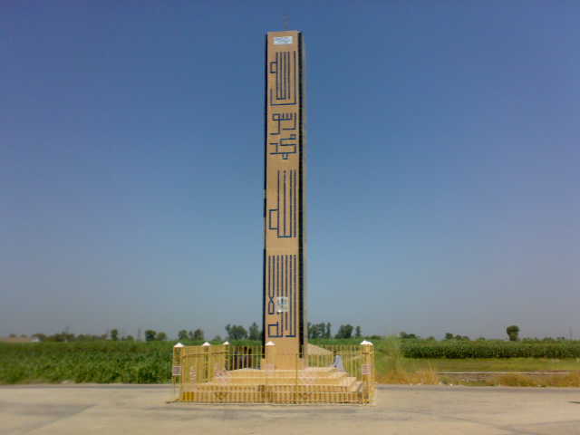 |
| Ghotki Tower |
 |
| Royel Inn Hotel |
 |
| Public Park |
 |
| Mosque |
 |
| Circuit House |
 |
| Jaamae Mosque |
 |
| Bus Stand |
By: Kavi Hassan (Rustam)


.jpg)


.jpg)


